Wednesday, 24 July 2013

Geomapix Gateway July Newsletter

Geomapix Gateway Monthly Newsletter
Issue
20

Follow Us

View Previous Newsletter

My Marketing Notes

Well it’s vacation time and I decided to write up a nice and light newsletter on a few things that I have been watching for the past month. I am heading on vacation this summer so, like everyone else, I am trying to get a ton of professional and personal tasks completed before our family leaves for a camping vacation to the beach. I have my hands full with a bunch of marketing ideas and campaigns for my business. One thing that I have realized in the past year is that when you have created a product like our Local Information Utility, you need to commit as much effort in marketing the product as you do creating the product. I have recognized that being and staying connected today is a lot of work whether it’s for business or personal. Information is being consumed at an alarming rate and people have a short attention span. So your message in any situation needs to be short and to the point. I am very techy in nature and in a sales and marketing scenario the techy talk does not work that well. As a business person I have a couple of great avenues to be able to meet people and chat on a professional and a personal level. I am comfortable with beginning conversations on a personal level and letting the chat take its course.


This leads to me and the person I am talking to getting comfortable and “what we do” or “what we sell” comes out naturally. So I think the goal is to be yourself at all times and try not to talk or look-like something that you are not. This leads into the development of some great soft skills which is an additional asset for any professional. One soft skill that is very important to me is to first listen to the person you are talking to.


Recently, I found a group called Sip.Chat.Connect (SCC) and it’s bringing Nova Scotia businesses together at local café’s or professional centres to chat about business. Founded by Charlie Aubie in the 2011, the Sip.Chat.Connect meetings are totally relaxing and everyone is very open to conversation. The SCC goal is to create a living and expanding network of businesses that not only meet together, but work together, to build a community of expertise for everyone to grow and learn from. They have weekly meet-ups in a variety of locations across mainland Nova Scotia and I see it spreading to other parts of the province. Note, the weekly meet ups are free to attend and are open to any business.


As Charlie puts it, “It's about shaking hands, asking questions, and making connections. We have so much to offer here, in this great province.” Charlie is so right! We have a wealth of untapped potential here in the province. The Nova Scotia business community is smart, innovative, and full of free thinkers that know what it takes to run a small business in Nova Scotia.

Please check out their website. Follow SCC


Techy Things We're Doing

GISbuzz.com has certainly created some buzz! Our Analyst and GISbuzz.com creator Phil Schnetzer shared some stats with me last week. His Google Analytics numbers show for the first month after launched there were 5586 visitors to the site and there were 16594 page views. These are great numbers for a one month launch.


Our partner, Gerry Watson, has been working with us on the development of a web based permit tracking system for small local government. We have officially named this product PermitLogix. Local government staff will never have to deal with managing “the paper trail” again. Permitlogix is fully customizable and we can consume your current permit requirements so you do not have to change the way you do things. The PermitLogix web interface will work with any major mobile OS using a standard data connection.


Also, Gerry works with businesses to develop interactive web sites such as the one he just created for the Middle Sackville Baptist Church, check it out middlesackvillebaptist.org


Speaking of Cloud, another business partner, Annapolis Valley Computers, is part of a new dynamic way for IT managers across the globe to manage thousands of corporate desktops without the infrastructure, hassle, or expense. They have partnered with Faktor11 of Ontario to offer their MokaFive desktop management solution. This solution that can run on any hardware platform. . . Mac or PC, desktop or laptop, personal- or corporate-owned. But can still be integrated into an enterprise Windows environment. Welcome to the new era!


Don't Forget, If your in the Halifax area and would like to network please check out my calendar at Meet Up Halifax.


Do you like this Article? Share It Below

Cloud GIS
 
GIS Project Management
 
 
News, Blogs, Video
 
 
IT Services
 
 
Annapolis Valley Computers
 
Web Design
 
Nova Scotia Networking
 

Wednesday, 10 July 2013

Meet Up Halifax Nova Scotia

Follow Us


View Previous Newsletter

I am visiting Halifax, Nova Scotia, every second Tuesday of the month to connect with professionals and chat about mapping, IT, web, social media marketing, and business

James Boxall, Director of the Dalhousie GISceince Centre has graciously offered a little space for me to hook up my laptop and connect with professional across Halifax. For a small firm like ours it is greatly appreciated :)

So if you work or are visiting Halifax on business I would love to chat with you. Please checkout our Meet Up Halifax webpage to check out our calendar for available times to meet. Click Here


Cloud GIS
GIS Project Management

News, Blogs, Video

IT Services


Annapolis Valley Computers
Web Design

Friday, 21 June 2013

Geomapix Gateway June Newsletter

Issue
19

Follow Us

View Previous Newsletter

GISbuzz.com

Our Analyst, Phil Schnetzer, recently created a cool website that consumes mapping related content from across the globe. He has rightly named the website service GISbuzz.com and tagged a slogan of “All things mapping”. Since going live on June 12 it has received thousands of hits and great feedback. The backbone of GISbuzz is a feed aggregator which continuously pulls new content from over 100 sources. The latest jobs, news, blog articles, videos and images are all available and can be read/viewed in their unaltered original state directly from within GISbuzz. If you produce GIS related content on the web that you would like to contribute to GISbuzz please visit his contact page.


GANS Conference

We recently took in a Geomatics Association of Nova Scotia (GANS) event in Halifax, Nova Scotia. GANS is a Non Profit Association that works to promote the Geomatics or map technology industry in Nova Scotia. I have been involved with the association for many years. As a small firm I cannot make it to all events but this event had particular significance to me. In a nutshell it started with a discussion about the future of Geomatics through the new group called the “Canadian Geomatics Community Round Table”, and was then followed by a presentation from Michael Goodchild, Emeritus Professor of Geography, University of California, Santa Barbara, called the “Future of GIS ”. He is widely credited with coining the phrase "Volunteered Geographic Information" and is considered the world's foremost expert on the topic.


James Boxall - Canadian Geomatics Round Table


Starting off is James Boxall, Director of the Dalhousie GISciences Centre and a member of the Round Table committee. It was an introduction to most of us on what this round table group is and explains that in the early days of Geomatics in Canada we played a fundamental role in the development of what we call Geographic Information Systems. Roger Tomlinson, the Father of GIS, created the first ever GIS system called the Canada GIS. Sure he was not born in Canada, but his roots in building the Geomatics industry started at the University of McGill. The round table is trying to understand why the Geomatics industry in Canada has fallen behind the rest of the world for innovation and leadership. 


One interesting piece was the discussion of the term “Geomatics” and if the Father of GIS created the Canadian Geomatics industry why isn’t the term “Geomatics” as synonymous as the word “Google”. The word Google is now a verb in the English language, why not “Geomatics” for the Geospatial world we now live in? Everyone knows the word “Maps”, but the word “Geomatics” Is just the start of a foggy conversation about the technology our industry uses. Is Maps too simple of a word? Is that why none of us in the industry can say we just make “Maps”? I think it’s perceived the word “Maps” may mean that what we do is not important to society.


Heck, it was certainly important in the days of exploring new worlds and all the survey and mapping work that David Thompson was so acclaimed for and was paid a good sum from the British Empire. In our profession we are explorers, surveyors, and map makers just in the digital context and more rapidly than in the past. For any Geomatics professional the elevator pitch to explain what we do would require a shaft that would reach the moon. The term Geomatics or GIS can spark a frenzy of technical jargon that literally stops time for the listener. When I am talking to someone that is not in my industry I say that “we make maps that can be delivered through the Internet to any client around the world with pretty much any kind of information that they want on the maps.”


But it was more than just the term Geomatics, it was about engaging the users on a study that looks at where the industry is right now. What are some of the road blocks in restoring our credibility as a leader? What are the factors that all levels of government, private sector, and higher education need to consider in reshaping our industry to standout and innovative?


These factors were discussed;


  • How is our industry identified? When we talk to people do they know or understand Geomatics and GIS or do we have an identity crisis?

  • Market? What are other countries doing in this field and what does the global market look like?

  • Business model? Where do public and private sector fit in the new Canadian Geomatics world of 2020 and who shall shape the spatial data of tomorrow? Who funds it?

  • Governance? Who makes the rules and leads the pack?

  • Where does the data come from? Does public sector carry the burden of the costs? Where does the public play a part in data capture. Does private sector take over the role?

  • Privacy? How do we protect the public’s privacy in a world where people are trying to get noticed and mobile applications are accessing our information without us really knowing it?

As you can imagine this discussion could have spanned days. The point obviously is for you, the reader, if you’re interested, to join the discussion. Because whether you are aware of it or not Geomatics, GIS, and map information is everywhere and is used without you even knowing it.


Please visit the round table resources by clicking below and don’t forget to check out their usual social media links. Visit http://eratosthenes-project.org/.


Michael Goodchild Lecture - The Future of GIS


Ok, I always said that I would not create a newsletter more than a page but I cannot help myself. Next, Dr. Goodchild lectured on the Future of GIS. Professionally, I needed to see this presentation so I could gauge, as an owner of a GIS consulting firm, if we are moving in the right direction. We are developing GIS products and services which are cloud based systems. A lot of financial risk and sweat equity has gone into our Geomapix Gateway service.


I am only going to highlight the key points for this article because it spanned 67 minutes and covered an enormous number of concepts in the GIS world. You definitely need to check out the video recording at http://spatial-information.org/goodchild-lecture/


Here are some of the highlights that I took from the lecture:


  • In Goodchild’s 45 year career GIS has been one of the most dynamic fields to work in.

  • New ideas for the use of GIS are endless and Goodchild had some great examples.

  • He says that we only have begun the exploration of GIS and that today is only a prologue to what is to come.

  • GIS technology is transitioning from the traditional 2d (Flat) mapping to visualizing data in 3D.

  • Advances in technology and the speed of the web have allowed us to better depict location information in real time and at a lower cost.

  • Real time tracking is a significant trend today because of our appetite for information and the rate at which we can consume it.

  • Tracking will also include not just location but collection data about the physical environment.

  • GIS web mapping technology has changed the way we collect data globally through open software and data concepts and that volunteers can contribute to a map.

  • One of the biggest advantages of open data concepts is the speed at which data is collected and consumed by users.

  • One of biggest challenges with open data concepts is the quality and reliability of the data.

  • The role of the GIS professional has changed because anyone can make a map now but that is countered by the fact it might not be a good map.

  • Mapping and geography is more user-centric than ever because of the reduction in cost to produce and distribute maps via the web and mobile.

  • The average person has been a consumer and a producer of Geographic Information by accessing things like mobile applications that consume and distribute your location to a community of people.

  • People want to map information of social significance such as their friends’ location, social dysfunction, and environmental issues.

  • Volunteers now can validate information in real time at the local level reducing the amount of ground varification required by the industry.

  • Computing has switched from desktop to remote or cloud based. Many things can be done more effectively within a cloud system.

  • The Cloud redefines a GIS from desktop software to a GIS platform.

  • The new GIS platform can access more information, from many locations around the world, all at the same time.

  •  Google has played a significant role in transforming the concept of GIS and bringing mapping to people anytime, anywhere.

  • Google’s service strategy is that there should be a little GIS in everything. So every service that Google offers could have a map view.

  • Cloud GIS is creating the mother of all databases, the Geo-Internet.

Finally, what we are seeing today is just the start of massive changes to geographic or place information becoming an integral part of our life.


Geomapix Gateway is on the right track and will continue to position and align itself to current needs while always looking ahead.


Do you like this Article? Share It Below

Cloud GIS
 
GIS Project Management
 
 
News, Blogs, Video
 
 
IT Services
 
 
Annapolis Valley Computers
 
Web Design
 

Wednesday, 19 June 2013

New Town of Kentville Street Maps


Follow us and stay up to date


As part of the ongoing development of the Town of Kentville GIS system, LGS Inc. created a street and downtown map of Kentville to be used in their promotional material and at their Visitor Information Centre.        


Powered By GeomapixVisit Landmark Geographic Solutions Inc


Geomapix Hosting Partner:


Do you like this Article? Share It Below

Thursday, 6 June 2013

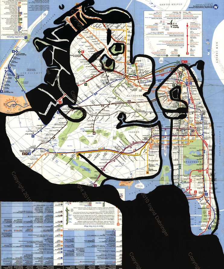
Ingrid Dabringer’s Map Paintings:Where Art and Geographer Find Each Other


Follow us and stay up to date


This is really cool! Ingrid Dabringer has combine art with geography using acrylic paint to interpret and draw characters and vignettes within ordinary maps.

You can order the originals or prints and would make a great conversation piece!

Check out the full article by Brainpickings.org


Powered By GeomapixVisit Landmark Geographic Solutions Inc


Geomapix Hosting Partner:


Do you like this Article? Share It Below

Friday, 31 May 2013

Kentville Farmers Market - Cool Market Map!


Follow us and stay up to date


View Our Newsletter


Technically not a map in the carto since but it is really nice! Kentville Farmer's Market Vendor Map.

http://kentvillefarmersmarket.ca/


Visually this map gives you a quick snapshot of the vendors within the market, the overall size, and great if you are looking for a particular vendor's wares. I have not gone yet put being a map guy will definitely headup on Saturday morning for some great snacks and product.


VIEW LARGER IMAGE HERE

Powered By GeomapixVisit Landmark Geographic Solutions Inc

Geomapix Hosting Partner:


Thursday, 23 May 2013

The Geomapix Gateway May Newsletter is Out! - Read about our project work and internship with COGS student Allen MacMillan


Issue
18

Follow us and stay up to date

Centre of Geographic Sciences: Student Final Term Project

Since 2009 our team has been working with the Centre Of Geographic Sciences (COGS) to provide graduating student a final term project and possible student internship.


Each year a COGS instructor contacts us to look at ideas for developing a work term. The goal is to create a real world project for the student so that they can get their feet wet when it comes to entering the GIS industry.

The process is completely professional and creates an opportunity for the sponsor to have a look at new GIS software processes and functions prior to implementing them across the business. The student gets a chance to build a project concept from beginning to end and build a project work plan, budgeting, and researching the proposed project. The final term project usually leads into an internship to prepare the student to enter the workforce.

Visit Landmark Geographic Solutions IncPowered By GeomapixOur 2013 student, Allen MacMillan, is a second-year cartography student with a keen eye not only for cartographic design but building a GIS and modelling for our project. Working with a local development authority we decided to look at a crop suitability model. The suitability model is based on growing hops for the brewery industry in the Annapolis Valley.

The goal was to identify the geographic data requirements and build a spatial analysis tool to identify a low, medium, and high potential of growth and put together a cartographically pleasing map product to be delivered to the Nova Scotia Agricultural Department.

By identifying data requirements we can understand what information needs to be collected or improved to build the suitability model correctly. Also by creating a Geographic Information System and analysis tool it will give the agricultural department the ability to expand their expertise in crop suitability mapping.

First off, Allen researched the best growing environment for hops; which is fast draining soils, South facing slope for sun exposure (using a TIN Model), a PH level of 5.6 or above, and excluded areas within 2 km of the shoreline. Other geographic data included identifying non forested and non wetland areas.

So Allen set out to create an Esri ArcGIS suitability model which became the heart of the entire project. Allen built the model so that values could be inputted into the model to build and output suitability areas for other crops.

The final touches are just about complete and we will be presenting the final map, GIS data, and modelling to the Nova Scotia Agricultural Department.

As a LGS Inc. intern, Allen is developing a Map Atlas generator using our Nova Scotia Geodatabase for Esri ArcMap. This will allow the production of custom maps for print and webGIS. Thank you Allen for all your hard work!

Please visit Allen’s portfolio website @ http://allenrm.com/


Like this?, Share it:


Share It @ GeomaticCanada.ca


submit to GeomaticsCanada.ca


Partner Profile: Gerry Watson of Snowbound Studios


We are always happy to identify partners that have made us successful. We're recognizing Gerry Watson of Snowbound Studios in New Minas, Nova Scotia, for his great work as our development partner.


Gerry has a keen eye for web design and has the uncanny ability to understand exactly what a client needs when it comes to web development. We have been able to work with him on a variety of GIS web applications including our flagship product, the Local Information Utility (LIU), the AGRG Community Mapping Project, and our new LIU product for a building inspection tracking system.

Gerry likes to learn, has a creative streak and wants to help solve problems. These are traits that can’t all be taught through higher education. Gerry sees the world as we do; that you can be a successful tech firm in rural Nova Scotia when you build local partnerships.

As a small firm it is difficult to be able to do all things tech. That's why LGS Inc. connects with small business expertise like Snowbound Studios because buying local and  growing the rural economy is important to us.

He sums his experience in web development quite nicely by saying;


“I am not a trained geek, it just came naturally, my education is in Geography and History, two topics that I still find deeply interesting BUT how does this make me suitable for web development? . . . I'm not sure - but I'm pretty certain it helps. I find this job requires a person, who likes to learn, has a creative streak and wants to help solve problems. These are traits you don't learn in school - well I didn't anyway.”

Gerry’s mission with Snowbound Studios is simple. He wants to work with people, talk to them, and help them realize their goals while continuing to foster his own personal and professional growth and development.

Visit Gerry’s website at http://www.snowboundstudios.ca/ or give him a ring at +19023652406

Geomapix Hosting Partner: